|
July 2010
Greater sage-grouse are in the spotlight this month—a conservation plan is in review and sweeping habitat work is underway across our eastern landscapes.
CONTENTS
Hunters Protect Aspen Grove on Malheur Forest
Ranchers Remove Juniper from 24,000 Acres of Sage-Grouse Habitat
New Dataset Available: Where Does the Deer Cross the Road?
The Conservation Registry Needs You
Endangered Columbian White-Tailed Deer Population Gets a Boost
Public Meetings on Sage-grouse Plan Slated
One Small Thing
 |
Rick Vetter, USFS, (left) and Rich Stutheit, OHA Capitol Chapter, at work on a buck and pole fence.
—Frank Harris photo.—
Click to enlarge |
HUNTERS PROTECT ASPEN GROVE ON MALHEUR FOREST
Oregon Hunters Association, the U.S. Forest Service and the Rocky Mountain Elk Foundation teamed up to protect an aspen grove and a spring in the upper Cow Creek area of the Malheur National Forest about 15 miles northeast of Burns.
On a summer Saturday, 20 OHA and USFS volunteers built a 60-inch-high buck and pole fence to keep livestock out of the spring while allowing wildlife to continue using it. The volunteers also repaired a nearby wildlife guzzler and fenced off several small aspen stands to protect them from over-browsing by livestock and big game.
OHA member Frank Harris helped initiate the project. “I started hunting in this area and fell in love with it,” he said, “I’m a habitat guy, so this was a great project for me. I look at the landscape now and think: what can we do for sparrows, what can we do for bats?”
OHA volunteers were from the Capitol and Harney County chapters. Funding for the project came from the Rocky Mountain Elk Foundation.
 |
Landowners received $2.6 million to remove juniper from 24,382 acres of high priority sage-grouse habitat.
—NRCS photo.—
Click to enlarge |
RANCHERS REMOVE JUNIPER FROM 24,000 ACRES OF SAGE-GROUSE HABITAT
The great sagebrush sea that greeted Lewis and Clark has dwindled to a fraction of its historic range across the West and with it sage-grouse populations.
“Sage-grouse do not exist without sagebrush,” said Christian Hagen, ODFW Sage-Grouse Coordinator. “To conserve birds, we have to protect what’s left of the habitat and fix what’s broken.”
Oregon still has a significant amount of sagebrush habitat remaining, most of it in Baker, Malheur, Harney, Lake, Deschutes and Crook counties. However, over 2.4 million acres of it has been “broken” by encroaching juniper. Juniper is a problem for a couple of reasons. When juniper moves in, sagebrush declines, and when trees appear in shrublands, avian predators, such as raptors and ravens, find perches that can lead to higher rates of sage-grouse mortality and nest predation. In fact, juniper expansion and wildfire are the two most pervasive habitat threats to sage-grouse in the state.
Aware that private landowners are a key partner in restoring sagebrush habitat, the Natural Resource Conservation Service and ODFW developed the Oregon Sage-Grouse Habitat Improvement Initiative with the goal of making measurable progress in reducing the threat of juniper expansion. This spring, NRCS held a sign-up for landowners to receive cost-share assistance to remove juniper through the Sage-Grouse Initiative. Financial assistance was awarded to 29 ranchers in the targeted counties who have high priority sage-grouse habitat on their land.
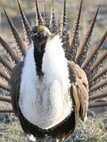 |
Greater Sage Grouse
-Photo by Nick Myatt- |
“We’re focusing on removing juniper in the early phases of invasion in areas within a three-mile radius of lek sites,” said Maestas.
Approximately 80 percent of sage-grouse nesting occurs within three miles of a lek site, or breeding ground, where birds gather in the spring to mate.
“By strategically focusing resources on removal of young junipers in critical locations for grouse, we have a chance to make the biggest difference in the shortest amount of time,” said Jeremy Maestas, NRCS State Habitat Biologist. “We’ve had our nose to the grindstone working with landowners to develop conservation plans since we kicked off the Initiative this spring.”
The Oregon Sage-Grouse Habitat Improvement Initiative is primarily funded by USDA Farm Bill programs: Wildlife Habitat Incentives Program (WHIP) and Environmental Quality Incentives Program (EQIP). NRCS, ODFW and other partners provide technical assistance to landowners in developing conservation plans while the programs provide payments to landowners to help offset the cost of implementing juniper treatments.
To date in 2010, the Initiative has provided $2.6 million to landowners to remove juniper from 24,382 acres of high priority sage-grouse habitat: 14,451 acres in Crook County, 1,772 acres in Lake County, 3,443 acres in Harney County and 4,716 in Baker County.
For information on the Oregon Sage-Grouse Habitat Improvement Initiative , visit NRCS’s website. Find the Greater Sage-Grouse Conservation Assessment and Strategy for Oregon on ODFW’s website.
 |
Sample map shows the priority linkages dataset. Red indicates highest priority areas where wildlife crossing work could be focused. The actual dataset is interactive.
—ODFW map.—
Click to enlarge |
NEW DATASET AVAILABLE: WHERE DOES THE DEER CROSS THE ROAD?
A new wildlife linkages dataset which shows key movement areas for wildlife, emphasizing places that cross paved roads, is now available. The dataset will benefit transportation and land use planners and conservation practitioners. It is available on ODFW’s website and requires ESRI ArcGIS Desktop or other GIS software to interact with the full dataset. Basic information can be viewed using a free viewer such as ArcGIS Explorer.
“The goal of this dataset is to answer the question: Where is the best place on the landscape to provide for animal movement?" said Miranda Wood, ODFW Conservation Strategy GIS Analyst.
The dataset is based on information obtained at workshops held throughout the state in 2007 and 2008 where biologists, transportation planners, land use planners and others met to identify linkage locations on the landscape based on animal movement needs that are essential to life history function. The locations were identified for individual species including large game mammals; small–to-medium-sized mammals; and amphibians and reptiles.
Data is available in either shapefile or geodatabase format to accommodate a range of software versions. The dataset, metadata, reports and a tutorial document for how to use the data is provided online.
The dataset addresses one of the key statewide conservation issues identified in the Strategy—barriers to animal movement. Find the tutorial and the dataset on ODFW’s website.
Contact Miranda, Miranda.L.Wood@odfw.oregon.gov
 |
A prairie restoration project on ODFW's Fern Ridge Wildlife Area will benefit the grasshopper sparrow and other grassland birds. See the project in the Registry.
—Photo: Dave Herr, USFS.—
Click to enlarge |
THE CONSERVATION REGISTRY NEEDS YOU
How does the conservation project you are working on fit into your watershed? Who’s fighting invasive species, providing fish passage or trying to bring back beaver in your area? Is anyone else in the state surveying for frogs? Find out on the online Oregon Conservation Registry. And, while you’re looking around, think about what project you could add to the website.
The Conservation Registry is free and easy to use. An online database and mapping system, the Registry allows you to enter, search and map your conservation projects. It’s based on Google Maps, which makes it easy to use and provides a familiar platform.
“It only takes about 10 minutes to get an overview of the site and see how it works,” said Kassandra Kelly, Defenders of Wildlife content manager for the Oregon section of the Registry. “It takes about 30 to 45 minutes to enter a project. The software is form-based and data entry goes very quickly if you have the information at hand."
Today, there are more than12,000 projects in the Oregon Registry—a good start but no where near enough. For example, in a search for “frogs,” only two projects were returned. For the website to be successful, a lot more people who are involved with habitat and species conservation will need to contribute.
There are many benefits to participating in the Registry—you can look at your project in the context of other projects, see the progress being made over time in a specific area, find projects in your area of interest and learn out how projects similar to yours are being funded.
 |
The Conservation Registry is a free online database and mapping system that allows you to enter, search and map your projects.
Click to enlarge |
By way of example, look at the Yaquina River Beaver Habitat Rehabilitation project. A Google map pinpoints the restoration area, project goals include invasive species removal and riparian replanting designed to attract beaver back to the area for the good of coho salmon. Partners and funding are included.
The Registry is truly easy to use. Unlike many websites that offer geographic maps, no GIS specific knowledge or software is needed. The Registry was launched in 2009 to capture the work being done in support of the Oregon Conservation Strategy and other state’s wildlife action plans.
The Conservation Registry is managed by Defenders of Wildlife with the support of many federal, state and local agencies, foundations and non-profit organizations. Visit the Oregon Portal of the Conservation Registry
Contact Kassandra, kkelly@defenders.org
ENDANGERED COLUMBIAN WHITE-TAILED DEER POPULATION GETS A BOOST
In an effort to bolster the endangered Columbia River population of white-tailed deer, agency biologists relocated eight deer from southwest Oregon to a national wildlife refuge along the lower Columbia River in Washington.
The fact that Oregon has Columbian white-tailed deer to capture and relocate is amazing in itself. When the species was federally listed as endangered in 1968, only a small population was known to survive on islands and a strip of land along the Columbia River. Ten years later, a small population was identified in Douglas County and was subsequently listed as endangered.
 |
Columbian white-tailed deer being transported from Douglas County to the Julia Butler Hansen Refuge in southern Washington.
—ODFW photo.—
Click to enlarge |
Plans were drawn and measures taken to recover both populations, and within two decades of being listed, the Douglas County population was in full recovery. It did so well that, in 1997, the Douglas County Columbian white-tailed deer was the first animal ever removed from the state endangered species list. By the time the population was federally delisted in 2003, there were an estimated 6,000 deer in the County.
“It was a big deal,” said Steve Denney, The Nature Conservancy’s south coast director and an ODFW biologist in the region at the time. “This was the first time a land mammal had been removed from the federal endangered species list.”
Deemed a “remarkable success” by the US Fish and Wildlife Service, the delisting was the result of conservation efforts by Douglas County, ODFW, the Bureau of Land Management and the USFWS. The Columbia River population, however, remained endangered.
“It’s risky to concentrate populations. We need to keep both of them strong.” said ODFW Biologist Tod Lum who managed the Douglas County deer capture. “Disease or a catastrophic event could put an entire population at risk.”
The deer were captured, disease tested, transported, collared and released in March 2010. After four months, six of the eight deer are accounted for and Paul Meyers, USFWS biologist for the Julia Butler Hansen Refuge where the deer were released, is pleased with the result.
“We know now that we can make this work,” Meyers said. “This was our first project and we hope to move more deer next year. It’s important to keep the refuge population from becoming isolated, and there is enough genetic variability between the groups to help.”
Julia Butler Hansen Refuge for the Columbian White-Tailed Deer
Columbian white-tailed deer: USFWS Fact Sheet
PUBLIC MEETINGS ON SAGE-GROUSE PLAN SLATED
ODFW will host a series of public meetings to present information and accept public comment on a five-year update to the greater sage-grouse conservation plan. Meetings will be held from 6 p.m. to 8 p.m. in the following locations: Lakeview, Aug. 3; Burns, Aug. 5; Baker City, Aug. 11; Bend, Aug. 18; Jordan Valley, Aug. 24; Portland, Aug. 26. See ODFW’s website for addresses.
The Greater Sage-Grouse Conservation Assessment and Strategy for Oregon is available to view on ODFW’s website . Request a print copy from the Wildlife Division, ODFW Headquarters, 3406 Cherry Avenue NE, Salem, OR 97303.Comments can be mailed to the headquarters’ address or e-mailed to sage.grouse@odfw.oregon.gov . See the news release.
ONE SMALL THING
Clean Water Services suggests you get a rain barrel to collect and store rainwater from your rooftop that would otherwise be lost to runoff and diverted to storm drains and streams. You can use the water for your lawn or garden or to wash your car.
PAST ISSUES OF THE NEWSLETTER
On the Ground newsletter archives
ABOUT THE OREGON CONSERVATION STRATEGY
The Oregon Conservation Strategy provides a blueprint and action plan for the long-term conservation of Oregon’s native fish and wildlife and their habitats through a non-regulatory, statewide approach to conservation. It was developed by ODFW with the help of a diverse coalition of Oregonians including scientists, conservation groups, landowners, extension services, anglers, hunters, and representatives from agriculture, forestry and rangelands.
EDITOR
Meg Kenagy
Oregon Conservation Strategy Communications coordinator
(503) 947-6021
meg.b.kenagy@odfw.oregon.gov
Join Oregon Wildlife Viewing on Facebook
To subscribe or unsubscribe, please e-mail the editor. Note: The use of trade, firm or corporation names and links in this publication is for the information of the reader. Such use does not constitute an official endorsement or approval by the Oregon Department of Fish and Wildlife. |

