|
|
 |
|
|
|
 |
|
|
|
|
 |
| A 2018 culvert replacement on Oak Ranch Creek, a tributary to the Nehalem River. This project improved fish access to 9.5 miles of habitat for cutthroat trout, coho salmon , summer and fall steelhead, Chinook salmon, and Pacific lamprey. Project partners included Upper Nehalem Watershed Council, Columbian County, OWEB, and ODFW. |
Smith River Basin Fish Passage and Restoration
During the summer of 2025, the Smith River Watershed Council
completed four voluntary fish passage and restoration
projects in the upper Smith River basin on the Oregon coast that will increase native migratory fish productivity and
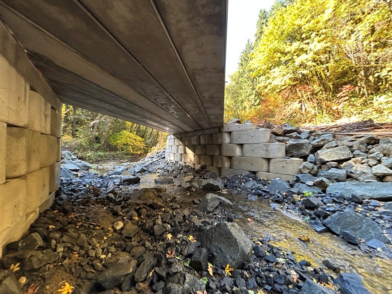
resilience. Two projects are located along North Sister Road. An undersized culvert in Sweden Creek was replaced with
a
modular bridge, and two concrete weirs were removed from North Sister Creek. Similar projects were completed along
West
Fork Smith River Road. A culvert in Coon Creek was replaced with a new larger stream simulation culvert, and concrete
weirs in the West Fork Smith River near the confluence with Coon Creek were removed. Combined, these projects improved
year-round access to 18 miles of spawning and rearing habitat for multiple species of native migratory fish including
Chinook salmon, Coho salmon, Steelhead, Cutthroat trout, Pacific lamprey, and Western Brook lamprey.
Removal of the concrete weirs and reconstruction of the stream channel in North Sister Creek and the West Fork Smith
River addressed two barriers listed on the ODFW
Statewide Fish Passage Priority Barrier List. Project designs and
construction were funded in large part by state Drought Funds and Fish Passage Compensation Funds administered by the
ODFW Fish Screening and Passage Program.
And that’s not all! Two more concrete weir removal projects and a culvert replacement project, designed using
Drought
Funds, are in the final stages before construction begins during the summer of 2026. Once complete, an additional 25
miles will be accessible to juvenile and adult native migratory fish in the North Sister Creek and West Fork Smith
River
subbasins. Future fish passage restoration projects are currently in design for Gold Creek, Blackwell Creek, and
Vincent
Creek tributaries that will continue to improve stream habitat for all native fish in the Smith River basin.
Project partners include the Smith River Watershed Council, Bureau of Land Management, Roseburg Forest Products,
River
Design Group/SWCA, Oregon Department of Fish and Wildlife, National Marine Fisheries Service, and the Oregon Watershed
Enhancement Board.
Quick Facts – Smith River basin
| 8 |
Native Migratory Fish |
| 232 |
Total known fish passage barriers |
| 6 |
Barriers on the 2025 Statewide Fish Passage Priority Barrier List |
| 13 |
Barriers addressed to date |
| 4 |
Barriers addressed in 2025 |
| 3 |
Barriers to be addressed in 2026 |
 |
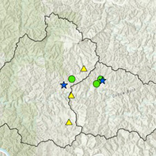 |
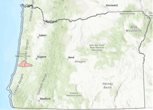
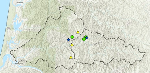
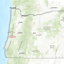
| The Smith River basin, located in the Coast Range, drains into the Umpqua River estuary near the City of Reedsport on
the Oregon Coast. The blue stars indicate the Coon Creek and Sweden Creek fish passage projects. The green circles are
projects planned for construction in 2026, and the yellow triangles are projects in design. |
|
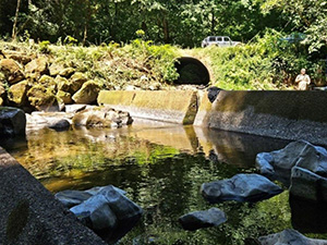 |
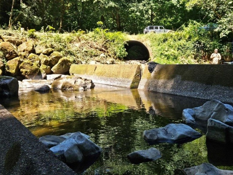
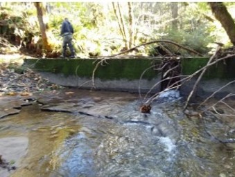
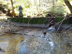
| Prior to construction, the streambed within the Coon Creek culvert was dry at low flows, disconnecting the stream from
the West Fork Smith River for extended periods of time. The concrete weirs, installed in the 1970s with the intention to
backwater the culvert, were fish passage barriers for juvenile salmonids in the West Fork Smith River. |
 |
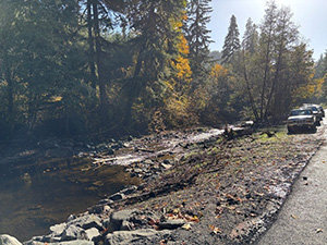 |
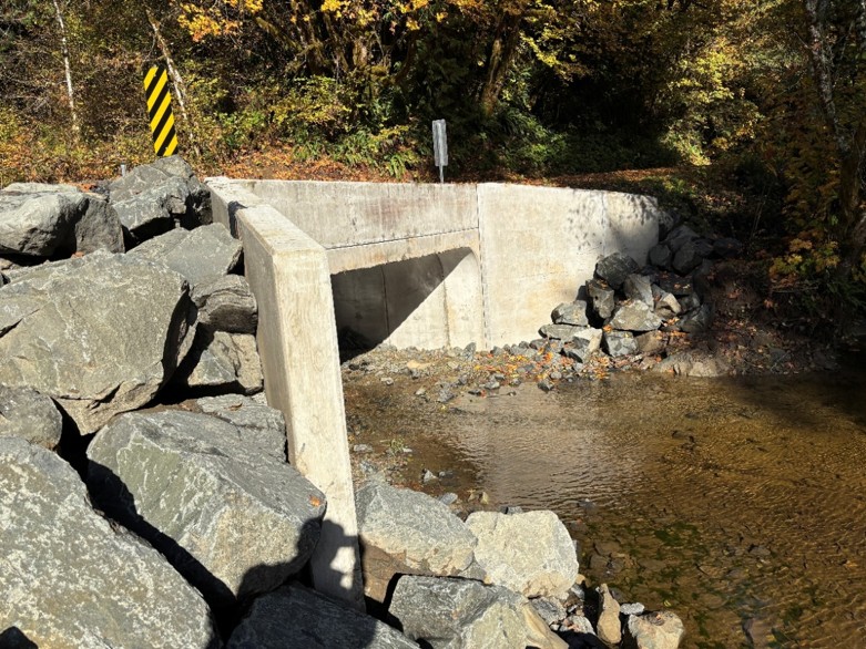
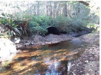
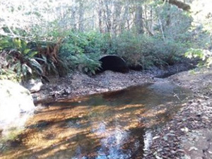
| Adult and juvenile salmonids and other native fish now have year-round volitional upstream and downstream passage within
both Coon Creek (top) and the West Fork Smith River (bottom) at all stream flows. |
|
 |
 |
| Prior to construction, the upper concrete weir on North Sister Creek was clogged with debris (left) and the gravel bedload at the outlet of the Sweden Creek culvert was a barrier to fish during low flows (right).
|
 |
 |
| Adult and juvenile salmonids and other native fish now have year-round volitional upstream and downstream passage in
North Sister Creek (left) and Sweden Creek (right) at all stream flows.
|
|
For additional information about the ODFW Fish Passage Program please check out our website or contact Mac Barr, ODFW
Fish Passage Coordinator, or Sharon Crowley, ODFW Assistant Fish Passage Coordinator. |
|
Little Eagle Creek Culvert Replacement
 This voluntary culvert replacement project on Little Eagle Creek restored fish access to four miles of habitat for coho salmon, steelhead, cutthroat trout, and Pacific lamprey in the Clackamas River basin. This project replaced a complete barrier to fish passage with a new culvert meeting ODFW fish passage criteria and the requirements of Oregon’s Private Forest Accord.
|
Culvert Repair Programmatic Agreement
 |
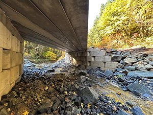
| Before and after pictures of a CRPA project on Canyon Creek, a tributary of the South Umpqua River. Prior to repair under the CRPA, the culvert had a significant perch at the outlet and high velocities during moderate and high flows. Fish passage was improved by reconstructing the downstream channel to backwater the outlet and adding fish blocks in the barrel of the culvert to reduce flow velocities. |
The Oregon Department of Transportation (ODOT) and the Oregon Department of Fish and Wildlife (ODFW) are implementing a five-year Culvert Repair Programmatic Agreement (CRPA) project that allows ODOT to make specific short-term repairs to culverts without having to meet full fish passage criteria at the repair location. ODOT now has the ability to
make critical repairs to aging culverts in a cost-effective manner, while providing a benefit to Native Migratory Fish (NMF) over the status quo by improving fish passage at each site repaired. In addition, ODOT paid $2.5 million into an ODFW-managed account that will fund the highest priority fish passage restoration projects off the state highway system. ODOT's culvert inventory has revealed that approximately 10,500 culverts are in poor or critical condition and need to be repaired or replaced in the near term to maintain the safety and integrity of the state highway system. Based on current estimates, it would require over $18.5 billion to replace all of the culverts under the state highway network. The typical design life of a culvert can range from 25 to 75 years. Based on current funding allocations, it would take 1,541 years to replace all of the culverts owned and managed by ODOT. Culvert repair work on fish bearing streams has largely been deferred over the past 17 years due to the inability to meet fish passage design criteria with a repair and the lack of available funding for full fish passage criteria replacements. Culvert repairs typically can be completed for $50,000 to $250,000. Culvert replacement projects that meet fish passage criteria can cost from $1.5 million to over $12 million each.
In 2021, five culverts were repaired under the CRPA. The total cost for these repairs was $850,540. The estimate to replace these culverts was $23.4 million. ODOT was able to defer over $22.5 million of cost to address these culverts by using the CRPA. However, this cost avoidance
should be evaluated relative to the design life provided by the approach. The repairs have added approximately 10-25 years of life to these culverts, whereas full replacements would have provided a new design life of 75 years. However, even given the difference in life span for the two approaches, life cycle costs are much lower for the repair option.
Fish passage improvements at the culvert repair projects used a combination of eliminating jump heights, increasing water depths, and decreasing water velocities. These projects improved access to over 19 miles of potential habitat for NMF. Additionally, part of the $2.5 million allocated to passage restoration was used to fund fish passage projects off the state highway system. A solicitation process was conducted in 2021. When completed, these projects will provide improved access to over 130 miles of potential habitat for NMF. Also, four projects selected for funding in 2019 were completed in 2021. Access to 98.5 miles of habitat will be improved through these fish passage restoration projects.
The CRPA continues to showcase how interagency coordination and collaboration creates positive outcomes. This mutually beneficial agreement allows ODOT to make progress in maintaining the aging state highway system, while also providing on- and off-highway ecological benefits to NMF. Taxpayer dollars are used efficiently for culvert repair work, and hundreds of miles of potential habitat for NMF are made more accessible.
Click here to access the CRPA GIS StoryMap, which presents annual CRPA project locations and summaries and illustrates how funding from the CRPA funding supports high-priority projects beyond the state highway system.
For questions relating to the Culvert Repair Programmatic Agreement contact Pete Baki at Pete.baki@odfw.oregon.gov. |
Fish Passage Mitigation Banking Pilot Project Final Report
 |
| The East Fork South Fork Trask Dam was removed as mitigation for 12 fish passage waivers as part of the Fish Passage Banking Pilot Project. The dam was the highest priority barrier on the North Coast. Once completed, the dam removal opened over 20 miles of habitat for coho salmon, fall and spring Chinook, winter and summer steelhead, coastal cutthroat trout, and Pacific lamprey. |
Between 2014-2020, Oregon Department of Fish and Wildlife (ODFW) and Oregon Department of Transportation (ODOT) partnered to develop the processes and tools necessary to pilot a fish passage mitigation banking program in Oregon's North Coast. Fish passage mitigation banking would allow ODFW to steer mitigation of impacts to passage from multiple, geographically dispersed waiver sites toward fish passage banks – locations where high priority barriers are removed and significant benefits for native migratory fish are created.
A Fish Passage Mitigation Banking Project Team comprised of ODFW Fish Passage staff, ODOT staff, as well as staff from The Nature Conservancy and Willamette Partnership (who were contracted by ODOT to provide technical expertise) lead the establishment of the Pilot. ODOT sponsored the development of a fish passage mitigation bank by removing the highest rated North Coast barrier identified on the 2013 Statewide Fish Passage Priority List located on the East Fork of the South Fork (EFSF) of the Trask River. Implementation of the Pilot took place between 2016-2018. Specific objectives of the Pilot were to 1) Rigorously test and refine the Net Benefit Analysis (NBA) Tool, 2) Conduct a limited number of fish passage mitigation banking transactions, and 3) Evaluate the potential for implementation of a fish passage mitigation banking program regionally or statewide.
Effective implementation of the Pilot required the development of a set of protocols and rules to guide use of the fish passage mitigation bank. These included defining a service area, creating a mitigation banking instrument, defining conditions or limitations on the use of the bank, and identifying criteria of success for evaluating the effectiveness of the Pilot in meeting overall project objectives.
Fish Passage Banking Pilot Final Report 2021 (pdf)
For questions regarding the Fish Passage Banking Pilot Project Final Report, please contact Pete Baki at Pete.baki@odfw.oregon.gov. |
The Opal Springs Hydroelectric Project (OSHP)
 The Opal Springs Hydroelectric Project (OSHP) is a 28.5' earthen-fill dam that was authorized in 1982 and commissioned in 1985. Salmon and steelhead were extirpated from the Upper Deschutes basin with the construction of the Pelton Round Butte Project (PRB Project) in the 1960s.Therefore, fish passage at OSHP was neither required nor provided at the time of licensing, as it is located upstream of the Pelton Round Butte complex. Instead, Article 36 requires the licensee to discharge a continuous flow of 50 cfs from the dam. In 2007, salmon and steelhead were reintroduced in the Upper Deschutes Basin, upstream of the Pelton Round Butte Project. For the first time since the 1960's, adult salmon and steelhead returned to the Upper Deschutes basin in late 2011. Reintroduction effort(s) was the result of the completion of upstream and downstream passage facilities at the Pelton Project. The reintroduced fish are repopulating three major tributaries to the Deschutes River – these include the Upper Deschutes River, the Metolius River, and the Crooked River. The Opal Springs Hydro Dam, located at the lower end of the Crooked River, is a passage barrier into this system, a very important tributary, which would otherwise provide significant spawning, rearing, and foraging habitat for these anadromous species. Bull trout, a federally listed species under the Endangered Species Act (ESA) are also present below the Opal Springs Project, which is considered critical habitat under the ESA. The Opal Springs Hydroelectric Project (OSHP) is a 28.5' earthen-fill dam that was authorized in 1982 and commissioned in 1985. Salmon and steelhead were extirpated from the Upper Deschutes basin with the construction of the Pelton Round Butte Project (PRB Project) in the 1960s.Therefore, fish passage at OSHP was neither required nor provided at the time of licensing, as it is located upstream of the Pelton Round Butte complex. Instead, Article 36 requires the licensee to discharge a continuous flow of 50 cfs from the dam. In 2007, salmon and steelhead were reintroduced in the Upper Deschutes Basin, upstream of the Pelton Round Butte Project. For the first time since the 1960's, adult salmon and steelhead returned to the Upper Deschutes basin in late 2011. Reintroduction effort(s) was the result of the completion of upstream and downstream passage facilities at the Pelton Project. The reintroduced fish are repopulating three major tributaries to the Deschutes River – these include the Upper Deschutes River, the Metolius River, and the Crooked River. The Opal Springs Hydro Dam, located at the lower end of the Crooked River, is a passage barrier into this system, a very important tributary, which would otherwise provide significant spawning, rearing, and foraging habitat for these anadromous species. Bull trout, a federally listed species under the Endangered Species Act (ESA) are also present below the Opal Springs Project, which is considered critical habitat under the ESA.
To address the issue of fish passage at Opal Springs, the owner (DVWD) entered into a Settlement Agreement with fishery agencies (including ODFW) and some non-governmental organizations to seek an amendment of the FERC license. The amendment allowed the DVWD to construct a fish ladder to provide volitional upstream fish passage and a series of gates that provide supplemental flows to aid upstream fish passage and provide a downstream passage alternative to the existing intake. These actions are monitored and evaluated against performance objectives, and a set of tiered adaptive measures are identified that will improve performance as needed.
The Opal Springs Fish Passage project is critical to the successful reintroduction of anadromous fish into the Crooked River watershed. Prior to completion of the vertical slot fishladder, approximately 80% of the returning adult steelhead attempted to migrate upstream in the Crooked River rather than the Deschutes River and Whychus Creek. Opal Springs Dam is located only 0.5 miles upstream from the Crooked River's confluence with Lake Billy Chinook. Passage at the dam provides access to over 120 miles of good to excellent spawning and rearing habitat. Previous efforts at temporary trap and haul facilities have been able to move approximately half of the adults that were detected at Opal Springst. Permanent volitional passage at Opal Springs is critical to successful reintroduction and meeting implementation goals set forth in the Mid Columbia Steelhead Recovery Plan. As such, passage at Opal Springs had been identified by ODFW in 2013 as the second highest priority passage project in the State.
Fish Passage at Opal Springs could also reestablish genetic connectivity for native redband trout, mountain whitefish, and sucker populations in the Crooked River with those of the Deschutes and Metolius Rivers. |
River Crossings on the East Fork of the Millicoma River
 In the late 1950’s, road construction removed two bridges and filled in two river crossings on the East Fork of the Millicoma River in Coos County. The change blocked water to more than ½ mile of stream channel, moving the river into a narrow chute. Water passed through the new chute much more quickly than through the historic channel becoming a severe barrier to fall Chinook and partial barrier to other migratory species. ODFW, Weyerhaeuser, The Freshwater Trust, US Fish & Wildlife Service, Oregon Watershed Enhancement Board, and Coos Watershed Association partnered together to install two new bridges and fill the channelized chute moving the river back into the historic channel. The project is complete and fish have access through the the ½ mile of reconnected historical stream channel and more than 16 miles of habitat upstream. In the late 1950’s, road construction removed two bridges and filled in two river crossings on the East Fork of the Millicoma River in Coos County. The change blocked water to more than ½ mile of stream channel, moving the river into a narrow chute. Water passed through the new chute much more quickly than through the historic channel becoming a severe barrier to fall Chinook and partial barrier to other migratory species. ODFW, Weyerhaeuser, The Freshwater Trust, US Fish & Wildlife Service, Oregon Watershed Enhancement Board, and Coos Watershed Association partnered together to install two new bridges and fill the channelized chute moving the river back into the historic channel. The project is complete and fish have access through the the ½ mile of reconnected historical stream channel and more than 16 miles of habitat upstream.
View a time lapse one of the bridges being built and after the river was reconnected |
|
|
|
|
|
|