|
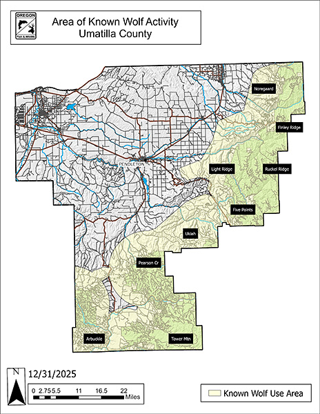
Current Umatilla County map (pdf)
Previous Umatilla County maps: 12/31/2024, 8/21/2024, 12/31/2023, 12/31/2022, 12/31/2021 (pdf)
Within Areas of Known Wolf Activity (AKWA) certain preventative measures are recommended to minimize wolf-livestock conflicts. Though not required, non-lethal measures are important to reduce depredation. If depredation becomes chronic and lethal control become necessary, ODFW’s ability to lethally remove depredating wolves will be dependent on the extent that non-lethal measures have been used and documented.
Click on each wolf group for more information:
The Arbuckle Pack spends most of its time in Morrow County. See Morrow County AKWA for more information.
Back to top
The Desolation Pack spends most of its time in Grant County. See Grant County AKWA for more information.
Back to top
The Five Points Pack spends most of its time in Union County. See Union County AKWA for more information.
Back to top
April 17, 2026 – The Light Ridge Pack was not documented as a breeding pair in 2025. A total of four wolves, including one pup, were
documented during the winter count.
April 11, 2025 – The Light Ridge group was not documented as a breeding pair in 2024. A total of three wolves, including one pup, were documented during the winter count.
April 15, 2024 – In 2023, OR30 dispersed from the Horseshoe area into the Five Points Pack. A new pair of wolves was documented using the Horseshoe territory during the winter count.
April 18, 2023 – Reproduction was documented during 2022; no pups were counted during the winter count, so the pack is not a breeding pair. Three wolves, including OR30, were documented during the winter count.
April 19, 2022 – In 2021, the OR30 wolves produced five pups that survived to the end of the year and was counted as a breeding pair. The OR30 wolves are now designated as the Horseshoe Pack.
April 21, 2021 – OR30 spent most of 2019 in the Wenaha Pack AKWA. In early 2020, OR30 was observed with another wolf in the Mt. Emily WMU. The new pair produced only one pup that survived to the end of the year and was not counted as a breeding pair.
Previous Horseshoe AKWA maps (for reference only): 12/31/2020 (pdf)
Additional information regarding OR30 can be found on the OR30 Wolves Timeline.
Back to top
The Noregaard Pack spends most of its time in Union County. See Union County AKWA for more information.
Back to top
April 17, 2026 – The North Emily wolves were not documented during the winter count.
April 11, 2025 –
The North Emily wolves were not documented as a breeding pair in 2024. A total of three wolves were documented during the winter count.
April 15, 2024 – The North Emily Pack was not documented as a breeding pair in 2023. A total of three wolves were documented during the winter count.
April 18, 2023 – In 2022, the North Emily Pack produced at least two pups that survived until the end of the year. The pack was documented as a breeding pair.
April 19, 2022 – In 2021, only two wolves were documented in the area during the winter count and were not counted as a breeding pair.
April 21, 2021 – In 2020, the North Emily Pack produced one pup that survived to the end of the year and was not counted as a breeding pair. The breeding male was not documented at the end of the year.
April 15, 2020 – In 2019, the North Emily Pack produced two pups that survived to the end of the year and was counted as a breeding pair.
April 8, 2019 – In 2018, the North Emily Pack produced five pups that survived to the end of the year and was counted as a breeding pair. Radio-collar data showed a 144mi² use area in the Mt. Emily WMU with 51%, 34%, and 15% of location data points on private, public, and tribal lands, respectively.
April 12, 2018 – In 2017, the North Emily Wolves produced at least four pups, but the status of the pups is unknown and were not counted as a breeding pair. An adult male was radio-collared in May and collar data showed a 130mi² use area primarily in Mt. Emily WMU with 79% of location data points on private lands.
April 10, 2017 – New wolf activity in 2016 was documented in the territory previously held by the Umatilla River Pack. Reports, sightings, and remote photographs confirmed the presence of three wolves in the area.
July 21 , 2016 – Since January 2016, two wolves have been photographed occasionally in the area previously used by the Umatilla River Pack. In late June, reproduction was confirmed via remote camera photographs of 2 pups. The AKWA map (dated 7/21/2016) shows the area typically used by wolves north of the Umatilla River where they are confined by geographic features and established neighboring wolf packs. Biologists will continue monitoring activities to learn more about these wolves.
Previous North Emily AKWA maps (for reference only): 12/31/2020(pdf), 12/31/2019, 12/31/2018, 01/31/2018, 07/21/2016 (pdfs)
Back to top
April 17, 2026 – Pearson Creek Pack was not documented as a breeding pair. A total of five wolves were documented during the winter
count.
April 11, 2025 - The new Pearson Creek Pack produced four pups that survived to the end of the year and was counted as a breeding pair. A total of six wolves were documented during the winter count.
August 23, 2024 - New resident wolf activity was documented in southern Umatilla County including confirmed reproduction via remote camera photographs of pups in July. Biologists will continue monitoring activities to learn more about the “Pearson Creek” wolves.
April 17, 2026 - The Ruckel Ridge Pack produced two pups that survived to the end of the year and was counted as a breeding pair. A total
of six wolves were documented during the winter count.
April 11, 2025 - The Ruckel Ridge Pack produced four pups that survived to the end of the year and was counted as a breeding pair. A total of seven wolves were documented during the winter count.
April 15, 2024 - The Ruckel Ridge Pack was not documented as a breeding pair for 2023. A total of three wolves were documented during the winter count.
April 18, 2023 – In 2022, three wolves were documented during the winter count, the group was not counted as a breeding pair.
April 19, 2022 – In 2021, the Ruckel Ridge Pack produced at least four pups that survived to the end of the year and was counted as a breeding pair.
April 21, 2021 – In 2020, the Ruckel Ridge Pack produced two pups that survived to the end of the year and was counted as a breeding pair. The previous breeding male died in May 2020, however by the end of the year a new breeding male was documented.
April 15, 2020 – In 2019, the Ruckel Ridge Pack produced three pups that survived to the end of the year and was counted as a breeding pair. Radio-collar data showed a 208mi² use area with 89%, 6%, and 5% of location data points on public, tribal, and private lands, respectively.
April 8, 2019 – In 2018, the Ruckel Ridge Pack produced at least four pups that survived to the end of the year and was counted as a breeding pair. Radio-collar data showed a 234mi² use area within the Mt. Emily WMU with 84%, 10%, and 6% of location data points on public, tribal, and private lands, respectively.
April 12, 2018 – The Ruckel Ridge Pack was a new pack in 2017. During 2017, the pack produced at least five pups that survived to the end of the year and was counted as a breeding pair. Radio-collar data showed that they are using an area previously occupied by the Mt. Emily Pack and used an area of 221mi² primarily in Mt. Emily WMU and 91% of location data points were on public land.
Previous Ruckel Ridge AKWA maps (for reference only): 12/31/2020, 12/31/2019, 12/31/2018, 01/31/2018 (pdfs)
Back to top
The Tower Mountain Pack spends most of their time in Union County. See Union County AKWA for more information.
Back to top
April 17, 2026 – The Ukiah Pack was documented as a breeding pair in 2026. A total of six wolves, including four pups, were documented in
the winter count.
April 11, 2025 – The Ukiah group was not documented as a breeding pair in 2024. A total of three wolves, including one pup, were documented in the winter count.
April 15, 2024 – In 2023, the Ukiah Pack produced at least three pups that survived until the end of the year and was counted as a breeding pair, with six wolves in the pack.
April 18, 2023 – In 2022, the Ukiah Pack produced at least three pups that survived until the end of the year and was counted as a breeding pair.
April 19, 2022 – In 2021, the Ukiah Pack produced at least four pups that survived to the end of the year and was counted as a breeding pair.
April 21, 2021 – The breeding male (OR60) and female of the Ukiah Pack bred for the first time in 2020. The pair produced four pups that survived to the end of the year and was counted as a breeding pair. Radio-collar data showed a 288 mi² use area with 46%, 45%, and 9% of location data points on private, public, and tribal lands, respectively.
April 15, 2020 – In early 2020, OR60 was observed travelling with another wolf in the Ukiah WMU. The AKWA will be modified if they den.
June 14, 2019 – OR30 dispersed from the AKWA in the Starkey and Ukiah WMUs in January. Since no wolves from the OR30 group remain in the area, the OR30 Wolves AKWA has been discontinued. A new AKWA has been designated for OR60, a disperser from the Ruckel Ridge Pack, that has visited the area repeatedly since January. OR60 appears to be alone.
Previous Ukiah AKWA maps (for reference only): 12/31/2020, 01/22/2020 – 08/20/2020, 12/31/2019, 06/14/2019 (pdfs)
Back to top
|

